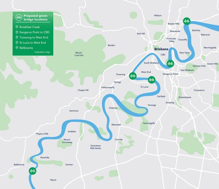
When Cr Adrian Schrinner first took over as Lord Mayor of Brisbane from Graham Quirk in 2019, he announced a $550 million plan to build ‘green’ bridges (for public and/or active transport only) at Breakfast Creek, from Kangaroo Point to the CBD, from Toowong to West End, West End to St Lucia and Bellbowrie to Wacol.
In late 2019, Council conducted an extensive consultation on the initial proposals, and they have now released the initial findings. More than 3000 pieces of feedback were captured, and 72% of respondents to an online survey agreed that green bridges will improve connections with existing walking and cycling networks.
The results will be presented to Council’s Public and Active Transport Committee this week, but here is our summary—with a particular focus on the Bellbowrie bridge, which is the most controversial of the proposals:
Interestingly, only the Bellbowrie bridge received any support for public transport. The community overwhelmingly said the remaining proposed bridges should be for walking and cycling only.

Not surprisingly, the Kangaroo Point to CBD bridge had the most support, since it has been discussed regularly over the last decade. Approximately 72% of people supported the preferred alignment from Alice Street to Scott Street.
The Breakfast Creek Bridge was supported, but not enthusiastically—since it’s really just an improvement to the existing crossing. Interestingly, a crossing between Newstead and Bulimba was actually suggested as more desirable.
A bridge between West End and Toowong—potentially landing at the old ABC site—was also very popular, with more than two thirds of feedback in support of the proposed location and 60% saying they would use the bridge daily or weekly.
The connection from St Lucia to West End was slightly less popular, with concerns about the lack of a connecting cycle network at West End, a potentially steep gradient, and impacts on green space on the St Lucia side.
The Bellbowrie Bridge
Feedback on the Bellbowrie bridge deserves a close look, as this was the most left-field suggestion—and in fact the only cross-river bridge not recommended in the 1926 Report of the Cross-River Commission. Public feedback reflected that, with only 20% of respondents indicating they’d use the bridge regularly, and less than 30% in support of the proposed alignment.
Being a low density, rural residential area with poor existing public transport in Moggill, it’s not surprising that there was a strong demand for the bridge to carry general traffic.

The eastern landing at deserted Wacol (near Grindle Rd) also raised eyebrows with feedback indicating a preferred alignment at Sumners Road, River Hills.
Grindle Rd, Wacol terminates at Wolston House and the Tick Fever centre, and currently you ride past the prison, weapons training centre, Wacol sewerage treatment works, and the disused rugby league club to get there. However Council has indicated if the bridge was to be built here, development of this land would be fast tracked.
A little further downstream, Sumners Rd ends at an elevated point above the river bank. There is existing roadway and patchy bike lanes and shared paths along Sumners Road to the Centenary Bikeway, so there would be far less cycling infrastructure required to build in addition to the bridge if it landed here. However, residents in River Hills are generally opposed to a bridge into their quiet neighbourhood.


 Across the river, a bridge connecting to Sumners Road would likely have to land at Booker Place Park (off Birkin Rd), displacing the dog park. That is something residents would rightly be concerned about, even though the bridge would be closest to the commercial centre of Bellbowrie.
Weekes Road (which is the logical connection for a bridge from Wacol) is a much easier landing, with the road terminating at an elevation above the river. That is also one of the reasons this location was proposed, as the bridge would likely remain usable in a 2011-style flood, whereas Birkin Road and the parkland there is badly affected by flooding.
Council have indicated they will do a new consultation specifically about the Bellbowrie Bridge in the middle of this year.
Council Committee Presentation
On Tuesday, 12 May, Council’s Public and Active Transport Committee is scheduled to hear a presentation about the Green Bridges Program. Members of the public can watch or listen online via Council’s YouTube Channel from 9:15-9:45am.
