
Getting about by bike should be safe and convenient. Where people have to ride on main roads they should be able to do so in a safe, separated and direct lane. Protected bike lanes on main roads will allow people to get where they need to go without feeling intimidated by traffic.
While Brisbane has some very good bikeways, often these only form part of a corridor, meaning people frequently need to ride on busy main roads to connect parts of their journey. Riding a bicycle on a main road is an intimidating and uncomfortable experience for most people and is the primary reason that many people are deterred from using a bicycle as a form of transport; they feel it is unsafe.
The perception that riding a bike is unsafe is cited internationally as a primary reason why many women choose not to ride. This effect has also been observed in different parts of Brisbane; for example on Sylvan Road at Toowong women account for only 10% of all riders compared with the Riverwalk where they make up 30%. Providing separated space on main roads will remove this barrier.
Space4cyclingBNE calls on the Brisbane City Council to support 100km of protected bikelanes by 2020 – including those listed below.
*Disclaimer –No part of this policy platform absolves Brisbane City Council’s responsibility to provide cycling infrastructure as part of road upgrades
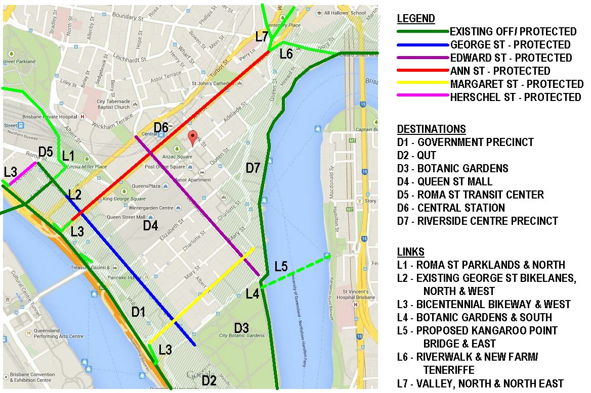
Brisbane CBD #minimumgrid
Ann St (1.5kms)
Qld Gov SEQ Principal cycle route
George St (900m)
BCC primary & secondary cycle route
Edward St (900m)
Qld Gov SEQ Principal cycle route
BCC secondary cycle route
Margaret St (700m)
BCC local cycle route
North
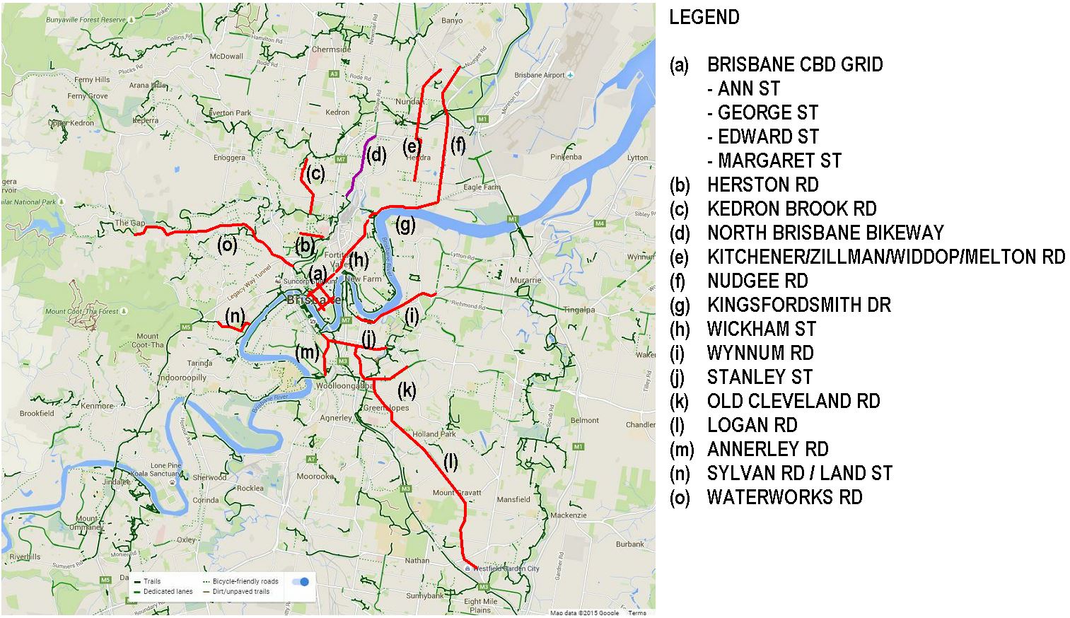
Herston Rd (900m) – Linking QUT Kelvin Grove to RBWH
Qld Gov SEQ Principal cycle route
BCC secondary cycle route
Kitchen/Zillman/Widdop/Melton St Rd (5kms) – Linking Northgate to Kingsford Smith Drive
Qld Gov SEQ Principal cycle route
BCC primary & secondary cycle route
Nudgee Rd (5kms) – Linking Northgate & Brisbane Airport to Kingsford Smith Drive
BCC Primary cycle route
Kingsford Smith Drive (3kms) – Linking Hamilton with Newstead
Qld Gov SEQ Principal cycle route
BCC primary cycle route
North Brisbane Bikeway* – Linking CBD with Kedron Brook Bikeway
Qld Gov SEQ Principal cycle route
BCC primary cycle route
Kedron Brook Road (2kms) – Linking Grange to Herston (and CBD)
Qld Gov SEQ Principal cycle route
BCC secondary cycle route
Wickham/Ann St – Linking the CBD,Valley to Newstead
Qld Gov SEQ Principal cycle route
South
Annerley Road (2kms) – Linking UQ, Yeronga, St lucia to Brisbane CBD
Qld Gov SEQ Principal cycle route
BCC primary cycle route
Logan Road (10kms) – Linking CBD to Mt Gravatt via Stanley St Proposed lanes
Qld Gov SEQ Principal cycle route
BCC primary cycle route
V1 Bikeway* – Linking CBD to Eight Mile Plains
East
Old Cleveland Road (2kms) – Linking Coorparoo to CBD via Logan Rd and Stanley St Proposed lanes
Qld Gov SEQ Principal cycle route
BCC primary cycle route
Stanley St (3kms) – Linking Coorparoo, Woolloongabba to Brisbane CBD via Goodwill Bridge Qld Gov
Qld Gov SEQ Principal cycle route
BCC secondary cycle route
Wynnum Rd (4kms) – Linking Kangaroo Point to Morningside
Qld Gov SEQ Principal cycle route
BCC primary cycle route
West
Sylvan Rd & Land St (1.5kms) – Linking the Western Freeway Bikeway to Bicentennial Bikeway (and CBD)
Qld Gov SEQ Principal cycle route
BCC primary cycle route
Waterworks Rd (8km) – Linking Ashgrove to Brisbane CBD
Qld Gov SEQ Principal cycle route
BCC secondary cycle route
* denotes council to work with & lobbying for Queensland Government to complete project
