Some more paths you might like to try, this time on Brisbane’s west side are the Ithaca Creek and Enoggera Creek Bikeways. These are great routes for hot days because they’re shaded and cool. But first, getting there…
I joined the closest bike path to me, which starts on Junction Road, Cannon Hill, just north of Cannon Hill Anglican College. The bikeway climbs up Lytton Rd on the southern side. There are slip lanes to cross at Barrack Rd, Creek Rd, and Metroplex Ave, and there’s a stupid squeeze point at the Gateway Office Park, but it finally brings you to the Metroplex Park Pathway which leads to the Brisbane River.


You’ll find a ghost bike on the corner, which is a tribute to 21 year old nurse Mardi Bartlett who was tragically killed in 2014 just a short distance up the road while riding with her training group. (The road has since been improved with the on-road lane).


You can take the on-road lane or the footpath straight up the hill to the Gateway Bridge from here, but if you have the time, the riverside approach is much less steep and more scenic. The Metroplex Pathway runs along the wetlands to the Brisbane River – where it unfortunately doesn’t yet link west to the Colmslie Beach Reserve – although EaST BUG are working on that. It runs past the new Brewdog Brewery, and the Murarrie Recreation Hub which has just reopened (replacing the old fishing pontoon at that location), to Queensport Rocks Park where it’s worth stopping to read some of the interesting history of the area. The view of the Gateway Bridges is impressive from here, and it’s also a good spot to grab a drink, as there is no water on the the bridge itself.


 From the park, there’s a gentle but steady climb to the bridge, and then a steeper climb up over the top. It’s worth stopping to check out the view, and with certain flight patterns you’ll be right underneath the planes coming in to land at Brisbane Airport. There are advisory signs calling for 10kph speeds on the descent – which is pretty unrealistic, since the adjacent road is 80kph and it’s a long straight stretch with excellent visibility.
Coming off the Gateway Bikeway at Lavarack Ave, turn left then cross the road for a path through to Kingsford Smith Drive. From there you’re back on-road, which can be intimidating even with the painted lane, since the road is busy with trucks. I turned down Theodore St to MacArthur Ave out of habit, but since the latest road widening, the on-road lanes on Kingsford Smith Drive to Remora Rd are quite good. Enjoy the fully separated bikelanes past Portside, demonstrating what is possible on Brisbane’s roads, and then the smooth flat ride along the new Kingsford Smith Drive Bikeway – even though it is quite hot and exposed.
From Breakfast Creek, there is a connection around to the Royal Brisbane and Women’s Hospital along the edge of the Inner City Bypass which is not marked on Google Maps. It wouldn’t take much to make this into a decent bike route – just a bit of footpath widening and decluttering, and some traffic signal upgrades.
Enoggera Creek Bikeway starts just north of the RBWH off Bowen Bridge Road. It’s a false start, as there’s a missing ramp at Victoria St, and you have to ride down Edgar St (despite what Google Maps says), but you’ll soon see the entry to the bikeway on your left. It passes through Downey Park, Finsbury Park and Spencer Park before dropping under Enoggera Rd via an impressive underpass.
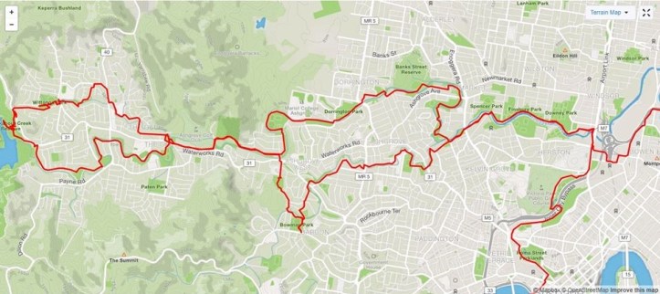
Ithaca Creek Bikeway separates from Enoggera Creek at Praed St (take the road, rather than crossing the bridge), and is a slightly more direct route west. It’s a lovely shaded pathway with multiple wide, high-quality bridges and underpasses.
 You can follow the path all the way to the base of Mt Cootha at Bardon, or climb up over the (steep) ridge at Sunset Park to rejoin Enoggera Creek Bikeway on the other side of Waterworks Rd at Gresham St.
Following Enoggera Creek upstream, there’s yet more high-quality pathway through The Gap, and (with a few quiet road segments) you can ride as far as The Gap Park n Ride facility and Enoggera Reservoir where you can cool off with a swim.
Across Mt Nebo Rd (and down a very steep path to Alutha Rd), there are more great cycling facilities along Fish Creek, until that runs into Enoggera Creek and the bikeway winds its way through Ashgrove to Newmarket and Wilston. You might get the feeling your Council rates have been spent here rather than closer to where you live; there are no narrow and rickety bridges or missing creek crossings here!


These paths are understandably very popular with people walking, jogging, exercising their dogs, and with kids learning to ride bikes and scooters – so please take care, slow down around others and prepare for the unexpected so everyone can have a great day out.
Returning to the RBWH at the end of the bikeway, you can ride up the wide footpath along Bowen Bridge Road past the hospital, and head in to the CBD along the inner-most section of the North Brisbane Bikeway: past Victoria Park Golf Course, over the Land Bridge, behind the Grammar Schools, through the tunnel at Normanby Fiveways and into Roma St Gardens.
