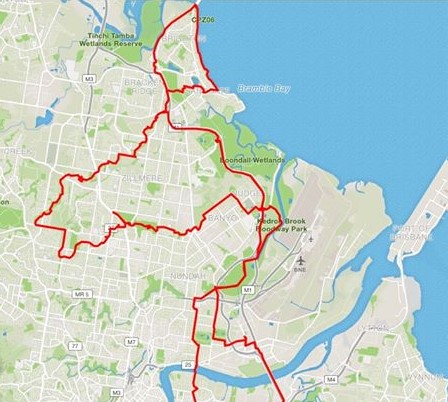
Today’s Brisbane bikeway adventure takes us to the north side, connecting the Gateway North Bikeway, Deagon Deviation Bikeway, Brighton/Sandgate Foreshore Path, Sandgate Bikeway, Cabbage Tree Creek Bikeway, Downfall Creek Bikeway, and Jim Soorley Bikeway.
We start at the southern end of the Gateway Bridge, at the top of Queensport Road – which climbs up from Murarrie Station. (Be careful at the top, as there is a lot of heavy vehicle traffic accessing the motorway and Lytton Rd.) You can stop to check out the confusing upside-down map of the Moreton Bay Cycleway, including all the “future path”. (When??)


Ride up over the bridge (see yesterday’s post), and follow the path through to Kingsford Smith Drive. If you want to stay off-road, you can cross at the lights there and take the “shared path” (widened footpath) on the northern side to Schneider Rd. Cross the slip lane (carefully) and the main road to find the shared path on the western side of Schneider Rd which will take you up and over the rail line. Look for the turn off on the left to double back to the path past historical Hangar 7 and through to Terminal Drive.


Unfortunately there are no good ways to reach the north side bikeways which completely avoid Nudgee Rd. (If the path from Schneider Rd to Viola Place existed, you could ride there via the Airport Precinct). You can take some back streets behind Doomben Racecourse, and the wide footpath along the front as far as Raceview Ave, but after that you’ll probably find yourself on Nudgee Rd, which gets increasingly hostile as you head north, and really nasty around the East-West Arterial. Once through that mess, you can finally breathe easily again when you reach the Schultz Canal Bridge: from here you can enjoy an almost totally traffic-free and continuous ride as far as Redcliffe!


Cross the bridge over Schultz Canal (which is actually the downstream end of Kedron Brook), and turn left and left again to head under the bridge and onto the Jim Soorley Bikeway. The first section is in relatively good condition, apart from a few weeds growing through the asphalt in places. A few kilometers along, you will come to an intersection where you have the option of taking the new Gateway North Bikeway or continuing on the old Jim Soorley Bikeway behind the golf course to Nudgee Rd. (Later in 2020 you won’t have that choice for a while, as the Jim Soorley Bikeway will be closed for work to stabilise the crumbling embankment).
Taking the Gateway North option, you now have a smooth and fast ride to Bracken Ridge. There are just two things to look out for: the signage at Bicentennial Rd is a little unclear; you need to take the first underpass to rejoin the bikeway on the northern side. At Depot Rd it’s again not obvious which way to go. Crossing at the lights is possible, but very slow. A better option is to continue west (along the southern side of Depot Rd) and then turn left to take the underpass to cross.


Once past Depot Road, you now have a smooth run on a mix of new and older sections of path alongside the motorway until that veers left at Bracken Ridge and things get a little weird. There are no signs to tell you that the underpass will take you north to the Deagon Deviation Bikeway. It’s easy to get lost like Doug (who I met changing a tyre and being eaten alive by mosquitoes) and end up doing confused laps of Bracken Ridge. The underpass itself is wide, well lit, and in good condition, but at its northern end the constrast to the quality of infrastructure you’ve just been enjoying couldn’t be more stark! No, you have not taken a wrong turn… pick your way through to the banana bars on the far side of Barfoot Street which herald the start of the Deagon Deviation Bikeway.


The Deagon Deviation Bikeway is another older path which was solidly built originally and holding up well. It’s shared, but there are not usually many people walking that way. It brings you to an underpass beneath the Redcliffe Bridges, and if you curl underneath, you can take the newest – the Ted Smout Memorial Bridge – across to Clontarf.


For a change of pace, and a lovely sea-side ride, you can take the Brighton and Sandgate Foreshore path south from here. Most of it has recently been upgraded to be smooth and wide, but there is still one section which is squeezy, and adult riders might feel better on the road. Being a seaside path, it’s busy with pedestrians and families on bikes and scooters – so totally unsuitable for fast riding. Chill and be prepared for the unexpected, or hop onto the road if it all gets too crazy.


Rather than continue around the Shorncliffe Peninsula (which has a steep climb back up to Shorncliffe Parade) I found the Sandgate Bikeway, past the Lagoons, through Deagon Sportsground Park, and along Racecourse Rd. From there, an underpass and the curly-wirly overpass connects back across to the Gateway North Bikeway.


My next mission was to follow the Cabbage Tree Creek Bikeway. To get there, I headed back under Deagon Road, then under Lemke Rd, across the new bridge, to the start of the bikeway at the Sandgate Hawks playing fields.


From Lemke Rd you can follow the Cabbage Tree Creek Bikeway south-west all the way to McDowall. There has been a lot of money spent in recent years on new sections of this path, and most of it is in excellent condition. The worst discontinuity is at Beams Rd where the bikeway is officially the northern footpath from the driving range, across the rail line as far as Balcara Ave. Then you need to find the path again at the back of the carpark behind the State Government Precinct at Carseldine, and use the footpath for a short stretch on Dorville Rd, Aspley.

After that, the quality of the path picks up again, with a relatively new underpass under Gympie Rd at Aspley, and new connections either side or Albany Creek Rd – although the crossing there only has a centre refuge and it can be quite a challenge to get across 2 lanes of traffic in each direction.


At Beckett Rd MacDowall, the crossing has gates on either side of the road to prevent the wildlife venturing onto the road. These are spring-loaded, but not too difficult to manage as there is plenty of room. (Alternatively, you can access the bikeway from Saturn Crescent)


From the end of the Cabbage Tree Creek Bikeway at MacDowall Reserve, I rode along east along Hamilton Rd, then south along Trouts Rd (which some people are keen to see become a future urban freeway – as if no-one has learned the lessons from the past 50 years of city planning…) to pick up the start of the Downfall Creek Bikeway on Trouts Rd, Everton Park.


Again, Downfall Creek Bikeway is a mixture of old and new pieces – some in excellent condition, and some much less so. There are a lot of road crossings with only a refuge island that can be difficult to cross when it’s busy or if you’re with kids or novice riders. (The worst of this is at Hamilton and Webster Roads).

At Gympie Rd, Chermside, the chain of pedestrian signals take forever. From there you can follow the bikeway north along Marchant Park – including possibly the widest bikeway bridge in Brisbane! Eventually, that path is supposed to continue through to Aspley, but after a number of years of talk, we have not yet seen any action from Council.
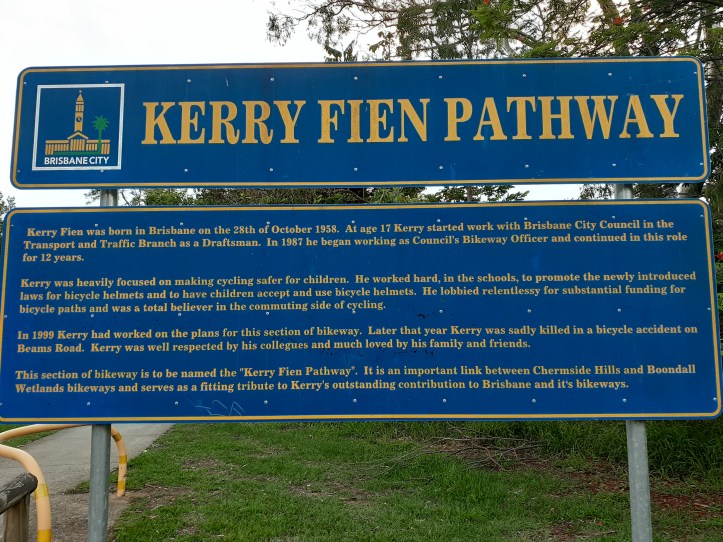
You can follow the Downfall Creek Bikeway all the way from Everton Park to Nudgee – although it can be easy to get lost – which is how I stumbled on this tribute to Kerry Fien, who was killed riding his bicycle on Beams Road in 1999. Would he be proud of the bikeways today, or frustrated with how much is still left to do after 20 years? (Perhaps both.)
At the end of Elliot Rd, Nudgee it looks as if the path was once intended to connect through to Boondall, but for the moment you can only cross the rail line at Nudgee Station and take the roads and paths through to Childs Rd, crossing at the lights to rejoin the Gateway North Bikeway at Nudgee Rd.


There is an offroad bikeway to Nudgee Beach I could have explored, but since it was growing dark, I took the Jim Soorley Bikeway back to Nundah – which I only recommend in the dark if you have a good headlight. (And don’t stop moving or the mosquitoes will suck you dry!)
Not keen to take on Nudgee Rd and the Gateway Bridge for the second time, I continued along the Kedron Brook Bikeway to Toombul, then took the path along Widdop St, and on-road along Zillman Rd, and Racecourse Rd (which would make a good bike route if only the street space wasn’t reserved for parked cars…) to Bretts Wharf Ferry Terminal for the intermittent and expensive toll-bridge (aka the CityCat) back to the southside.
