With episodes of flash flooding since Thursday, there have been traffic delays all over the city—including to public transport. Cycling is still the most adaptable, reliable and quickest way to get around—although you’ll need good mudguards and waterproof gear to keep dry; or good end of trip facilities.
Of course many of our separated bikeways and shared paths are built along creeks and quickly become impassable, so you’ll likely need to find alternative routes. If you are out on the bike, be careful of slippery surfaces and potholes, and be aware that many people still don’t drive to conditions.


Council Candidates

The threat of rain didn’t deter Claire Garton, Greens candidate for Moorooka Ward, from joining Belinda for a bike ride around Rocklea and Salisbury early on Saturday morning. Despite some of these paths being under water in the days before and after, we stayed dry.
Claire used to cycle everywhere as a young adult but since getting her licence, having a family, and giving away her bike to someone in need, she hasn’t ridden in recent years and feared her fitness wasn’t up to scratch. She did well today on a heavy, unfamiliar bike! The good news for anyone in Claire’s situation is that fitness returns quickly with regular rides, and electric bikes are game-changers on hills.
Belinda and Claire cycled along some pleasant shared paths and quiet back streets, but retreated to the footpaths in a few places to stay off main roads on their loop. During the week, these roads are extremely busy, with a lot of heavy vehicle traffic.


The Ipswich Motorway Cycleway will be a great new connection into this area, and (in a few years) Rocklea Station will be upgraded as part of Cross River Rail to make it fully accessible, and hopefully to provide secure bike parking enclosures. But there’s still a lot more needed: completing missing connections, lighting existing paths to make them safer at night; fixing footpaths that are narrow, cracked and overgrown; and providing more places to safely cross roads like Muriel Ave.
Earlier in the week, Labor candidate for Enoggera Ward, Jonty Bush, joined Stephen from Brisbane North BUG for a bike tour along Kedron Brook and surrounds. She got to see how through traffic impacts on the rideability of local streets – as well as the dangers that have been built into the new Kedron Brook and Days Road intersection “upgrade”. Jonty was very supportive of active travel and strongly cognisant that we need to really prioritise bikes if we want to make our city more liveable.


During the ride, Jonty made this video which really captures the problem with too many roads in Brisbane; even where there are painted bike lanes, they deliver you into the back of a parked car so you need to move out into fast moving motor vehicle traffic to get around. It’s these types of issues, on important routes like Kedron Brook Road, which put a lot of people off from cycling altogether.
Thanks to Jonty for highlighting the issue. This is why we’re so keen to get council candidates out for a bike ride before the election. There are great opportunities for improving healthy transport in Brisbane, but we need a council which treats it as a priority, not an after-thought.
V1 Veloway
 To address some of the issues raised in discussions about the “velobridge” announced last Friday, we are keen to see a feasibility study for a ramp joining the Veloway to the Woolloongabba Bikeway at the intersection of Stanley St and Trinity Lane. There appears to be room to shift the freeway off-ramp lanes to the right (hopefully without even having to alter the intersection at the bottom), and turn what is currently the left lane into a bikeway using concrete barriers. That ramp would have a much shallower gradient than either the current skinny path to Trinity Lane, or the ramp that causes so much heartbreak from Lower River Terrace.


Riders accessing the Veloway from the Goodwill Bridge could then have the option to take a flatter route via Stanley St and this new ramp, or to avoid the lights (which are terribly timed for outbound cyclists) by riding up the steeper hill from Lower River Terrace. And what are the possibilities for widening and easing the gradient of that ramp in the space available next to the expressway?
Perhaps these ideas have already been assessed and rejected? We’d like to understand what options analysis was done before the Velobridge announcement, where $1.6 million has been awarded for a planning study.
Victoria Park
 On Tuesday, Council’s Public and Active Transport (Etc) Committee was given a presentation on the Victoria Park Draft Vision – Active Travel Opportunities. It’s good to hear that in initial community engagement, the need for better bikeways and connectivity was raised as one of the 5 top themes. Many users highlighted that the current routes through and around the park are complex and often difficult.
One of the three guiding principals in the draft vision is reconnection; stitching the parkland back into the city. It identifies the key routes through the park and destinations at the edges – including the CBD, Roma St Parklands, the RBWH and start of the North Brisbane Bikeway, Kelvin Grove Village and the QUT campus, and the connection to the Enoggera Creek Bikeway and cycle routes to the north-western suburbs via Aberleigh Rd.
The “connections” section of the vision suggests an east-west link that would connect the Land Bridge to QUT Kelvin Grove approximately along the ridge line, and a north-south link inside the western edge of the path. However only the first of those is explicitly shown in the “Illustrative Concept” map, which is concerning.

In the presentation, and in response to questions from councillors, it was stressed that the intention is for the cycle paths to be 3m wide, and “shared” routes to be 6m – with 3m for walking and 3m for cycling clearly delineated. We see that as a positive indication that Council have heeded the message from other problematic areas of the city. (*cough* Howard Smith Wharves, South Bank)
We will be providing feedback highlighting these positive aspects of the proposal, and stressing the need to provide for good commuting connections as well as opportunities for recreational activities within the park. We encourage others to also jump online, take at look at the Draft Vision document, and provide feedback. There is a survey which is open until 28 April 2020.
(This week’s committee presentation was given by Council’s Chief Planner, Dyan Currie who was recognised in this year’s Honour’s List as a Member (AM) of the Order of Australia for significant service to town planning and strategic urban development. Congratulations Ms Currie AM.)
Elsewhere around the suburbs
Thanks to Stafford MP Dr Anthony Lynham for recognising the importance of the Frederick St bridge in Alderley as a local walking and cycling connection. We hope Dr Lynham can assist in ensuring the community is not left without this vital active transport link for much longer.
In the spirit of celebrating the small victories, here’s one for our file of “Things which are no longer rubbish”: the culvert where Beams Rd crosses Cabbage Tree Creek at Taigum. There was previously no real footpath on the northern side of this bridge at all. But works last year saw the culvert widened and a 2.5m shared path installed. Much better!


EaST BUG reported a tiny piece of good news on Stanley St East: the build-out island just before the pedestrian crossing near Withington St has now been reduced in size, leaving just enough room to squeeze past without having to move right out into the general traffic lane.
Our petition for a 2-way protected bikeway on Stanley St East was considered in Council’s Public and Active Transport Committee meeting this week, and the response sounds likely to be some positive noises that Council recognise the importance of this corridor. However we share the frustrations of Jonathan Sri, Councillor for The Gabba: we need more than positive platitudes; it’s time for action. There is room on this corridor, it’s time to get serious about prioritising healthy transport!
In Other News
This is a great initiative from the Yarra City Council in Victoria. With support from the state Transport Accident Commission (TAC) they have set out to educate people about the benefits of reducing speed limits on neighbourhood streets to 30kph, and to debunk the myths. In particular:
Research shows that reduction in speed limits in urban areas has minimal impact on travel time. Travel time in built-up areas is related to how much time is spent slowing and stopping at intersections, parking and in local congestion. Maximum travel speed has very little to do with travel time in these areas.
This is what leadership at a local government level looks like instead of just playing to political populism.
Hate traffic? Here’s how to fix it in five easy steps:
- Make streets multimodal
- Implement congestion pricing and/or limited traffic zones
- Eliminate street parking
- Boost transit options
- Reclaim plazas and other public space for people
Dates for the diary
 It you live or work on the north side, make sure you get along this week for one of the community consultation sessions about stage 4 of the North Brisbane Bikeway. Head along to 128 Bridge Street, Wooloowin (the vacant block opposite Wooloowin Train Station) and tell the TMR team how much you’re looking forward to a safe, separated cycling route connected via Dickson Street.
- Session 1 4.00pm – 6.00pm, Wednesday 12 February 2020
- Session 2 8.00am – 10.00am, Saturday 15 February 2020
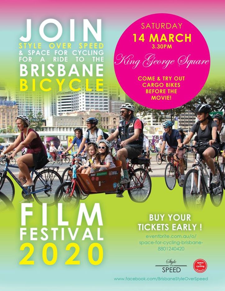
Once again, our friends at Brisbane Style Over Speed have organised a ride to get you to the Brisbane Bicycle Film Festival 2020 on March 14 in style, leaving from King George Square at 3:30pm. The Style Over Speed Ride will arrive at UQ in time to check out the cargo bikes at the Brisbane Cargo Bike Expo from 5-6pm. And of course, don’t forget to get your tickets for the screening of Motherload and the finalists in the Brisbane Bike Bites Short Film Competition.