- State election campaign
- CBD Cycleways
- Bridges
- Bikeway Enhancements Program
- Sign up for a car free New Farm Park
- Around the suburbs
- Park it for the Planet
State Election Campaign
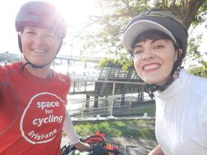
Our political candidate of the week was Amy MacMahon who is running representing The Greens in South Brisbane. Taking advantage of a beautiful morning on Wednesday, Belinda and Amy went for a ride around East Brisbane, Kangaroo Point, Woolloongabba, Dutton Park, and South Brisbane. Starting near Lytton Rd in the morning peak is a good reminder that road-widening is a useless strategy for “busting congestion”, and focusing on “traffic flow” can lead to really bad outcomes for local residents simply wanting to cross the road to access shops, services, schools, and public transport.


Belinda and Amy checked out the landing site for the new cross-river bridge at Scott St, Kangaroo Point, and some of the connections to it that desperately need improving: the dead-end riverwalk from Mowbray Park, the underpass with stairs from Deakin St, and the lumpy footpaths along Shafston Ave, Deakin St, Main St, River Tce, Leopard St and Vulture St.
Skirting around the edge of the Woolloongabba Station construction site, we took the busy Veloway to O’Keefe St, then rode behind the PA Hospital and squeezed past Dutton Park Station to check out the site of the future bridge that will join the PA Hospital Bikeway to the Boggo Rd precinct. Next stop was the new Inner City South State Secondary College construction site, and a chat about planning for active school travel as the top priority, not an afterthought.


It’s great to see major infrastructure projects progressing, but important they deliver improvements to the local area, not just funnel more people through the inner city suburbs. Facilities that make it safe and pleasant to walk and cycle shouldn’t require hundreds of hours of determined advocacy from volunteers either; we need elected representatives who will make it their priority too!
CBD Cycleways
Our dream of a bike-friendly city centre is finally getting close to reality. This week, the Brisbane Times reported that Brisbane City Council has committed to building a “Citylink Cycleway“, which Cr Ryan Murphy describes as “a system of protected, dedicated bikeways within the CBD.”

While it seems Brisbane has missed the boat to use popup bike lanes like we’ve seen in other cities around the world, it’s encouraging to hear Council, and Minister for Transport and Main Roads, Mark Bailey MP getting behind permanent solutions to the last kilometre of travel for people getting into and through the CBD by bike or scooter. We’re confident that the two levels of government working together can achieve a great outcome for Brisbane.
It’s especially encouraging that Cr Murphy acknowledges and accepts there will be trade offs in regards to parking. There are thousands of car parking spaces in the CBD, but less than 300m of protected bike lanes. As Cr Murphy says:
“ultimately, this is worth it, because we know more and more Brisbane residents are getting on their bike.”
On Thursday morning, Cr Murphy spoke on ABC Brisbane Radio about Council’s plans for the “CityLink Cycleway”. Stage 1 will involve Elizabeth St between William St and Creek St, and Edward St from Elizabeth St to Alice St. Consultation will be happening in September, with construction due to start in November.

Cr Murphy highlighted how on-street parking isn’t the best use of public space in the city, and how protected cycleways will allow people to move safely by bike and scooter; it’s not about the stereo-typical “lycra warriors” but about people of all ages and abilities being able to get where they need to go. This is an exciting change in the way Brisbane moves, and the callers agreed. (Well said Chris from Jindalee and Paul from Sandgate!). Protected cycleways in the CBD are definitely on our Christmas wishlist!
Listen to what Cr Murphy had to say here from 1:48:40 and feedback from 2:19:10
Bridges
On Tuesday Lord Mayor Adrian Schrinner announced plans to fast-track the CBD to Kangaroo Point active transport bridge, with the aim to complete it in 2023.
We’re happy to see that the draft reference design shows separated space for people walking and people cycling/scooting, and also indicates shade cover for the walkway and plans to preserve the lovely tree at the Scott St landing.
This seems very positive, and we look forward to this long-anticipated link, which will cut up to 3km from trips from the eastern suburbs to the CBD, Botanic Gardens, and QUT.
Also announced, procurement will soon be underway for a new walking and cycling bridge across Breakfast Creek. A concept design will be released for community consultation next week. We understand that the bridge will cross the creek diagonally, and that the project will include an extension of the Lores Bonney Riverwalk – which will be very welcome, as the current shared path is quite narrow. We’re certain no-one will miss riding on the narrow and bumpy footpath on the current Breakfast Creek Bridge.


As always, connections matter, so we hope this project will also improve the connection up Breakfast Creek to Sandgate Rd and over to Bowen Hills, and that it will link to improved paths through Newstead.
It’s great to see active transport being taken seriously by all levels of government, with Member for South Brisbane, Jackie Trad MP weighing in about Victoria Bridge. We certainly appreciate the desire for shade on the walk across Victoria Bridge, but also wonder how feasible it will turn out to be to retrofit a 50 year old concrete bridge not designed for the additional weight and wind-loading. With an alignment similar to the Goodwill Bridge there would also be similar issues with shade moving across the bridge during the day.
It is much easier to design a new bridge with shade structures, so we were pleased to see that included in Council’s concept design for the new CBD to Kangaroo Point Bridge, but surprised it wasn’t included in plans for the Neville Bonner pedestrian bridge to Queens Wharf.
We’re also wondering: if a shade structure can be retrofitted to the Victoria Bridge, can a bicycle-path structure be added to the Captain Cook Bridge? We’d love to see a connection directly from the Veloway into the CBD!
Bikeway Enhancements Program
This week, Council’s Public and Active Transport Committee heard a presentation on the “Bikeway Enhancements” program – which is basically all bike-related projects which aren’t actually about building new bikeways. These include:
BIKEWAY LIGHTING: Current projects include the Southern Bikeway at Tarragindi (completed recently), and the Norman Creek Bikeway between Deshon St and Gladys St. This program has also replaced existing lighting with LEDs, which have approximately 60% less power usage, and also allow for better control of colour and lighting temperature to make paths feel safer.


WAYFINDING SIGNAGE: Upcoming work will aim to improve signage around the river loop.

BANANA BAR REMOVAL: Council don’t actually have an inventory of all that were installed, but it was believed to be around 1100 sets around the city. They apparently prioritise removing those they receive most complaints about. (We mapped and prioritised around 800 sets, but it seems BCC prefer to wait for individual complaints). Councillor Angela Owen raised the problem of unauthorised trail-bike use on paths and in parks which is a real problem in her ward of Calamvale. Unfortunately the new bollards don’t prevent that any more than the banana bars did. (We’re not aware of any simple engineering arrangement that can prevent trail bikes without also preventing access for people with cargo-bikes, tandems, kids trailers, wide prams, etc.)
BIKE PARKING: There was mention of 200 racks and 35 locations (which doesn’t sound like many, so maybe our scribe misheard?), with a focus on sites adjacent to shops, services, libraries, sporting venues, transport stations, etc. 14 of the “green heart” racks have been installed around the city centre. (Councillor Steven Huang asked “do they come in red?”).


LIVE BIKEWAY MONITORS: Council have 20 non-display counters, and 8 display monitors. Display counters were activated last week on Tank St and Annerley Rd. Wynnum Rd and [another location] will be activated soon.
(Speaking of there monitors, we noticed that the counter on Annerley Rd is now operating, but its mate on Stanley St was blank. These counters seem to have real issues with reliability, which is a shame – some of us enjoy following the numbers.)


ACTIVE SCHOOL TRAVEL PROGRAM: Currently 41 primary schools are taking part in this behaviour change program.
CYCLING BRISBANE: Another behaviour change program, but aimed at adults. Started in 2014, with free sign-up, offers deals with sponsors on things like discounts on bike purchases, coffee, etc. Currently has 26,500 members.
Sign up for a car free New Farm Park
This petition calls for closing the road in New Farm Park to motor traffic so it can be used by people to safely exercise, socialise, or relax while keeping a healthy distance. The coronavirus pandemic has highlighted the value of local spaces, and cities around the world are reclaiming their parks for people ahead of cars.

The ring road in New Farm Park is not actually a gazetted road; it is essentially a pathway. That’s good news as it negates any normal hurdles to closing a road to motor vehicles. For those who have no choice but to drive, free parking is available in the adjacent streets and in the Powerhouse carpark which was recently upgraded by Brisbane City Council.
You might wonder why motor vehicle traffic and parking were ever allowed to dominate so much of New Farm Park. Years ago, cars were allowed to drive through the Brisbane City Botanical Gardens too, but that would be unthinkable now. It’s time for New Farm Park to become a place of refuge, shade, and peace!
Around the Suburbs
Last week, Council’s Public and Active Transport Committee heard a presentation on the Indooroopilly Riverwalk, which is currently under construction and on track for completion in late 2021. What was glossed over was that to fully realise the potential of this piece of infrastructure, it needs a safe connection along Lambert Rd, and a safe way to cross Kate St to reach the Centenary Cycleway at Witton Rd.

The first of these issues is quite simple, if not easy. Reducing the speed limit and amount of on-street parking on Lambert Rd only requires political will. People will ride if it feels safe, but the threat of being squeezed between parked cars and moving vehicles puts people off. Improving Lambert St for active transport shouldn’t have to wait until the riverwalk connection is completed either; it’s a key link to the Jack Pesch Bridge, and is already well used.
Spotted near the University of Queensland last weekend:
- A cyclist on the footpath because the road feels like an urban freeway.
- A scooter rider also on footpath because he’s not legally allowed on the road (but probably wouldn’t want to be there anyway)
- A woman with pram waiting multiple cycles to get across the road.
- A desire line worn through the grass to Munro St—the shortest route towards the ferry terminal.
- Plenty of foot traffic even on a Sunday afternoon
- A woman on a mountain bike walking up a hill on the “perfectly good parallel route”.


Please add your signature to this petition asking that Brisbane City Council review their plans to further expand the intersection of Sir Fred Schonell Drive and Coldridge St, and instead focus on taking meaningful steps to make alternative modes—like cycling, scooting, walking, and taking public transport—safer and more comfortable and convenient!
On the east side there was evidence of a high speed crash on Lytton Rd, East Brisbane some time on Friday, outbound just before the Canning Bridge. We haven’t been able to find any further information about what happened, but if anyone was on the footpath at the time that would not have ended well!!


There was positive news amongst discussion in Council’s meeting this week, with one of the issues discussed being a subdivision of land to enable delivery of the Wakerley Bikeway. From the papers:

“The Wakerley Bikeway project will improve safety and access for cyclists and pedestrians along Rickertt Road, Ransome. The project will involve:
– installing a new shared path between Green Camp Road and Chelsea Road along the northern alignment of Rickertt Road
– installing a bikeway crossing upgrade at Chelsea Road
– installing a new bridge decking structure over Lota Creek.”
East BUG have no further details just yet, and are not aware that budget has been allocated for the project, but this could be very good news for people cycling and walking on the eastern edge of Brisbane.
In the south, we’re pretty excited about the Ipswich Motorway Cycleway opening. Not that we’ve been impatiently checking on progress or anything…


The Department of Transport and Main Roads have advised that the signals at Suscatand Street will be switched on during the week starting 24 August, and “In the coming weeks, the separated cycle path and shared pedestrian/cycle path either side of Ipswich Road service road will also become fully operational.” Woohoo!

(We do note that for the moment, the connections at either end of the new path aren’t great, and the underpass at Oxley Creek is not scheduled to be open until the late this year.)

Park it for the Planet
Cars make up more than half of Australia’s total transport emissions, yet more than half of the car trips we make are shorter than 5km. Bicycle Network are encouraging everyone to ditch the car and get on their bike, scooter, skates or walking shoes to replace short car journeys, and #ParkitForThePlanet.
Join the #FightForPlanetA and get involved in Park it For the Planet Day on August 26. Indeed, why wait; why not start today!
Finally, let’s finish this week’s wrap with a great story from the UK about how closing the street to motor vehicles – and opening it to people – can be great for local business.
